161,835 oz/gold
FY21 Total Production
7 years
Life of Mine
2.33 million oz/gold
M&I RESOURCES
1.32 million oz/gold
P&P Reserves
Exploration – Organic Growth Pipeline
Perseus has an ambitious exploration program with a strong pipeline of prospects close to each of our operating mines, demonstrating the Group’s potential for organic growth. The exploration program is focusing on targets within the existing mine permit, and/or within trucking distance, that have the potential to organically increase the resources and reserves, and ultimately life of mine at our existing operations.
Perseus regularly releases exploration updates to the market; these can be found in the Investors and Media section of the website
YAOURÉ GOLD MINE - CÔTE D’IVOIRE
Perseus holds a number of exploration and exploitation permits with prospects within the Yaouré Gold Mine project area.
Recent exploration has focused on resource definition, geotechnical and metallurgical programs at the CMA Underground North Plunge Prospect; Yaouré Open Pit Deposit, Zain 1 and Zain 2 Prospects as well as highest priority regional exploration targets on the Yaouré West Exploration permit.

Geology
The Yaouré Project lies within the Paleoproterozoic Birimian-age Yaouré greenstone belt in central Côte d’Ivoire. Greenschist facies supracrustal rocks in the Yaouré district consist mostly of an assemblage of pillowed and massive mafic lava flows. These rocks are oriented NNE to NE, dip steeply towards the SE, and are intruded by a number of small plugs, sills and dykes ranging from mafic to felsic in composition. Immediately north of the deposit, this gold-bearing sequence is structurally juxtaposed to a distinct volcano-sedimentary basinal assemblage that includes basaltic volcaniclastic rocks and dacitic sandstones deposited as a series of mass and pyroclastic flows with minor episodes of high energy fluvial activity.
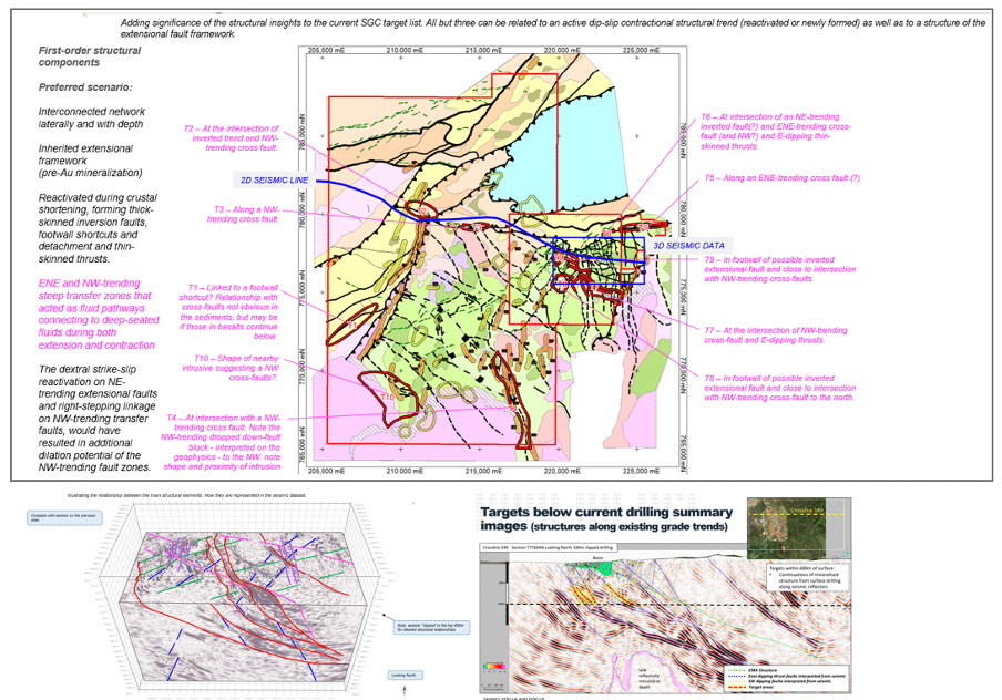
Gold mineralisation in the Yaouré district is hosted by Birimian metabasalts and felsic intrusive rocks. The most significant deposit, the CMA deposit, is hosted by a major mineralised reverse fault system, the CMA thrust structure that strikes N-S and dips at 25 to 30 degrees to the east. CMA mineralisation is distinguished by pervasive, moderate to strong, pink-pale brown albite and carbonate alteration developed within a well-defined slip zone marked by one or several deformation textures with quartz carbonate veins, fault veins, multi dilatant fault breccia, cataclasis and shearing. The combined alteration and vein package ranges up to 15 metres in true thickness. Data from the 3D seismic survey indicate the CMA structure extends more than a kilometre down dip from the known CMA deposit and exploration is currently focused on investigating the potential for additional resources at depth.
The adjacent intrusive-hosted Yaouré deposit comprises mineralisation controlled by east-dipping structures, similar to the CMA, in addition to mineralisation associated with quartz-tourmaline-chlorite-carbonate veining controlled by NE and NW striking, sub-vertical faults and also stockwork quartz veins with associated alteration selvages hosted by a granodiorite intrusive body.
The CMA SW and Kongonza prospects lie on interpreted southern extensions of the CMA thrust structure where it bifurcates into SW and SE branches. The CMA SW structure strikes NE and dips at about 30 degrees toward the SE. Mineralisation comprises gold associated with pyrite in a quartz-albite-carbonate alteration assemblage in metabasalts. The mineralised structure is typically 6-8 metres true thickness. At Kongonza, gold is associated with quartz veining and silicification in a structure striking NNW and dipping at about 40 degrees east. At low gold grade thresholds (e.g. 0.2g/t) the Kongonza mineralisation is up to 70 metres true thickness but potentially economic grades are generally limited to 10-15 metre true thicknesses.
The Govisou prospect is underlain by andesitic basalts intruded by granodiorite bodies. Mineralisation occurs as disseminations of pyrite and arsenopyrite in the granodiorite and in quartz-carbonate veins in both the intrusive and basalts.
The CMA East prospect consists of CMA-like structures in the hangingwall of the CMA thrust identified from 3D seismics where these structures are interpreted to project to surface.
The Degbezere prospects are located along a major regional shear zone around 15-20km west of the CMA area. The geology there comprises mafic volcanics locally intruded by granodiorite bodies. The geology of the nearby Allekran prospect, defined from soil and auger geochemistry, is also underlain by mafic volcanics locally intruded by granodiorite bodies.

SISSINGUÉ GOLD MINE - CÔTE D’IVOIRE
Perseus’s exploration pipeline for the Sissingué Plant includes the Sissingué and Fimiasso Exploitation Permits, the Mahalé Exploration Permit and the Bagoé Exploration Permit. The Fimbiasso, Mahalé and Bagoé permits are outside of the existing Sissingué mine permit but within trucking distance of the Sissingueé plant.
A review of historical data identified a number of high priority near- mine targets, which are being followed up with mapping, geochemical sampling and RC/DD drilling programs. Recent work at Fimbiasso West and Airport West have added significant ounces to the LOM.

Geology
The Sissingué Permit is located within Paleoproterozoic (Birimian) rocks of the central part of the Syama Greenstone Belt. The geology of the area is dominated by clastic basinal metasediments intruded by major felsic (granodioritic) and minor mafic to granodioritic intrusions, traversed by predominantly NNE-trending shears and faults.
Gold deposits in the Sissingué district are of the orogenic, greenstone-hosted type. Gold mineralisation at the Sissingué Gold Mine occurs predominantly within a plug-like granodiorite intrusion and felsic dyke system intruded into a metasedimentary assemblage of argillite, siltstone, sandstone and heterolithic sedimentary breccia and conglomerates along a 700-metre-long x 250-metre-thick NNW-trending corridor. Although mineralisation is focused on the granodioritic plug and dykes the metasediments are also strongly mineralised, particularly above the main granodiorite body. Gold occurs within a strongly developed quartz-carbonate vein system with associated carbonate + sericite + albite + pyrite ± arsenopyrite alteration.
In contrast, the Mahalé Permit is located on the western margin of the Syama Greenstone Belt, with gold mineralisation localised along the sheared contacts of a magnetite-rich syenogranite intruded into mafic volcanics. At Fimbiasso East, NNW- to NS-trending ore lenses are oriented at a low angle or sub-parallel to steeply E-dipping faults and associated foliation, while at Fimbiasso West ore lenses are associated with an ESE-trending and gently NW-dipping thrust fault system and associated low angle fractures. Both deposits developed where rheological contrasts between the rigid intrusive rocks and the surrounding volcanic rocks formed favourable conduits for hydrothermal fluids. Gold mineralization is characterized by zones of disseminated pyrite with rare quartz-carbonate vein stockwork, with a distal biotite-chlorite-magnetite alteration overprinted by a proximal hematite + microcline + albite + pyrite + quartz assemblage.
The Bagoé Permit covers an area in which the Syama and Senoufo Birimian greenstone belts converge. Both belts comprise sequences of metasedimentary rocks, felsic-intermediate volcaniclastics and lesser basaltic rock, along with tonalite and granodiorite intrusions.
The Antoinette deposit is hosted by a metasedimentary unit that includes thin intercalations of carbonaceous metasediment. The unit appears to have been the locus for deformation in a sequence of felsic and andesitic volcaniclastic rocks that lie close to the eastern margin of the Syama Belt. Mineralisation extends over a strike length of ~800 metres with widths up to 30 metres.
The Juliette gold deposit is located 3.5km SW of Antoinette and is also hosted by the Antoinette sequence/structure. Mineralisation is subvertical, extends over about 300m strike and generally comprises a single lens 4-10m wide.
Mineralisation at both Antoinette and Juliette comprises pyrite and arsenopyrite associated with silicification, relatively low volumes of vein quartz and very strong sericite and iron carbonate alteration. Most gold is refractory and probably occurs in solid solution in arsenopyrite and possibly loellingite (FeAs2).
The Brigitte prospect is located ~2-3km NE of Antoinette and is hosted by the extension of the Antoinette sequence/structure. Mineralisation appears to lie between mafic volcanics to the NW and mixed diorite and sediments to the SE.
The Véronique deposit, located about 15 kilometres SSE of Antoinette, is hosted entirely within a hornblende granite that is probably located within the Senoufo belt. Mineralisation is centred on a single, 1-6-metre-wide structure that hosts a metre scale stylolitic quartz vein carrying visible gold and traces of pyrite. The vein is surrounded by a 2-3-metre-wide zone of sheared and sericite and iron carbonate altered granite carrying some stringer veins. Mineralisation extends over 900m strike and dips at 45 degrees to the SW.
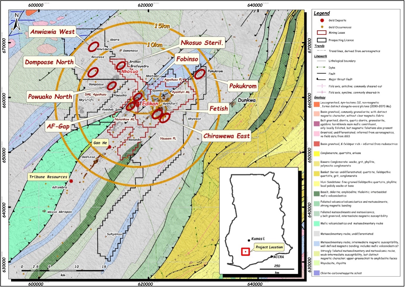
EDIKAN GOLD MINE – GHANA

Edikan holds a total of 425.56 sqkm land, all located within the Kumasi Basin close to the western margins of the Ashanti Belt this includes 2 mining leases and 5 Exploration permits. Near mine environment relatively mature in terms of exploration history but increases in gold price present new opportunities. Exploration program at Edikan is focusing on targets within trucking distance of Edikan with potential to increase life of mine. Exploration is focused on generating and then testing mineralised intrusive bodies within structural corridors.
Geology
The Edikan Mine and associated exploitation permits are located in the Asankrangwa Gold Belt and is underlain principally by Paleoproterozoic (Birimian) flysch-type metasedimentary rock sequences comprising dacitic volcaniclastic rocks, greywackes and argillaceous (phyllitic) sedimentary rocks that are intensely folded and faulted and metamorphosed to upper greenschist facies.
Gold deposits in the Edikan area are of the orogenic, grey and greenstone-hosted type. Most deposits in this region are controlled by structures cutting Birimian metavolcanic and metasedimentary rocks and/or granitoids of the Eburnean Plutonic Suite.
Alternating seismic and interseismic episodes of deformation created an environment favourable for gold mineralisation. Gold mineralisation at Edikan occurs predominantly in the form of high-grade quartz veins, or vein stockworks, in fractured rock associated with brittle deformation, or in low-grade disseminated sulphide mineralisation comprising arsenopyrite and/or pyrite, within shear zones which have undergone ductile deformation. There are also auriferous quartz veins and stockworks in Birimian metasedimentary and metavolcanic rocks, Eburnean granitoid plugs and dykes.
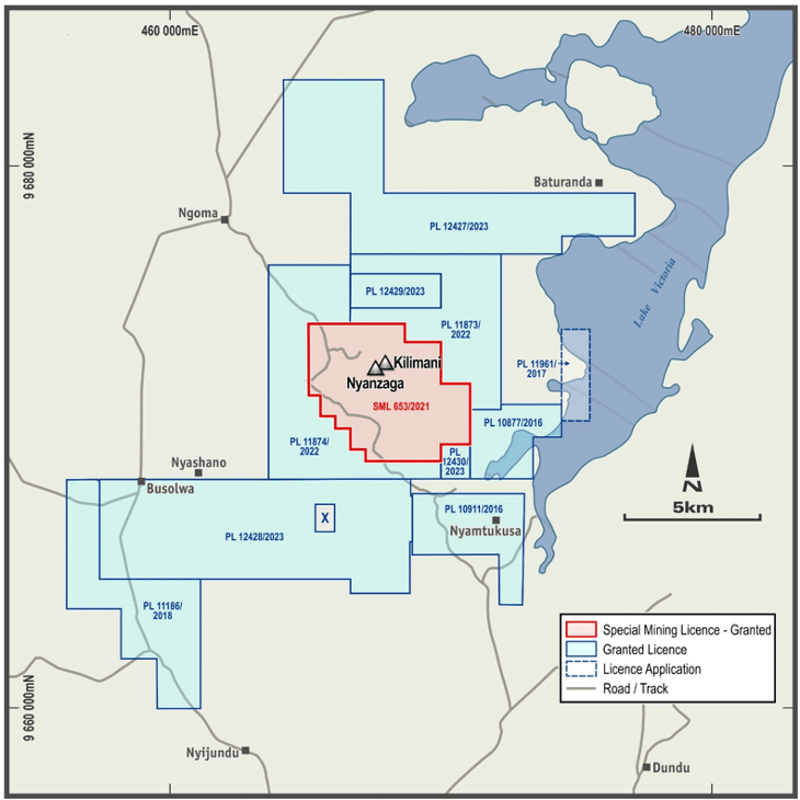
NYANZAGA GOLD PROJECT – TANZANIA
The Nyanzaga Gold Project consists of one Special Mining Lease (SML), nine granted prospecting licences, and one prospecting licence application. The primary focus for the past year and in the coming year will be resource development activities designed in further defining and derisking the resource and will include resource reserve infill drilling as well as geotechnical, metallurgical and site sterilisation drilling and associated technical studies.
Regional exploration on the SML and surrounding PLs continues with mapping programs, geochemical surveys and RC/DD drill programs designed to evaluate priority targets undertaken.
GEOLOGY
The NGP is situated on the north-eastern flank of the Sukumaland Greenstone Belt. Rock sequences comprise Nyanzian-aged sequences of mafic volcanics in the far south-west and banded-iron-formation, tuffs, mudstone, sandstone and epiclastics of general volcanogenic origin and massive sulphide lenses and volcanics of rhyodacitic to andesitic composition. The sequences are tightly folded and strike generally west-northwest.
In the central part of the NGP, the Nyanzaga and Kilimani groups are defined. The Nyanzaga Group is divided into a sequence of three broad mappable units from drill core and outcrop mapping and are in stratigraphical order as follows:
- Nyanzaga Upper Volcaniclastic Formation.
- Nyanzaga Central Formation.
- Nyanzaga Lower Volcaniclastic Formation
These three units are folded into the north-northwest plunging Nyanzaga Anticline. These sequences are in turn overlain by the Kilimani Group which appears to be tectonically dislocated from the underlying Nyanzaga Group by faulting and potential earlier thrusts.
A series of different faulting sets has been recognised across the Nyanzaga project area. These include observed outcrop positions with suggested sinistral movement; others with inferred dextral movement; a series of steep faults sub-parallel to bedding; and a number of low angle thrust faults. Additionally, east-west trending normal faults with minor displacement have been identified.
The interaction of these various fault orientations results in the definition of numerous fault block domains. The geological model has focussed on those faults where evidence is observed across multiple sections, and therefore likely to have influence on the geological model at a resource scale. Small scale and discontinuous features are expected to be present but unlikely to materially influence the position of mineralisation within the project.
The two mineralisation systems show similar alteration and mineralisation styles, though the Kilimani deposit is interpreted to have been emplaced at shallower levels than at Nyanzaga. Typical alteration features include pervasive carbonate alteration, varying from distal ferroan-calcite to proximal ankerite-sericite dominated and quartz-pyrite alteration. The current interpretation indicates that there is a distinct lithological control and most of the gold appears to be hosted by iron rich sediments in the form of an extensive stock-work of carbonate, quartz veins, and quartz-carbonate breccias. Preferential grade enhancement occurs in selected altered units such as the thick cherts, silica-dolomite altered medium grained sandstones, brecciated silica-carbonate altered mudstones, or in the late quartz veins as free gold.
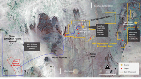
MEYAS SAND GOLD PROJECT – SUDAN

The MSGP is situated in the far north of Sudan, approximately 75km south of the border with Egypt, and is fully permitted by the Sudanese Government with a Mining Lease, Royalty agreement and a water permit formally granted incorporating attractive fiscal terms, and clearly delineated rights and obligations of key stakeholders.
Since the acquisition of MSGP, Perseus made strong progress towards preparing for a possible FID on the MSGP in the second half of 2023. However, in late April 2023, following the outbreak of armed conflict in Sudan, largely in and around Khartoum, between the Sudanese Armed Forces and an influential militia group, the Rapid Support Force, Perseus withdrew most of its employees from the MSGP site pending a resolution of the conflict with the safety of its staff being the number one priority for the Company.
To date, Perseus has focused exploration activities on the MSGP at the GSS prospect and specifically at GSS Main and GSS East deposits. Results received to date, while incomplete, are viewed as encouraging and give a degree of confidence in the current foreign estimate. Detailed geological and resource modelling work has been undertaken and we have advanced our understanding of geology and mineralisation including geometry, grade distribution and variability, metallurgy, geotechnical aspects.
Exploration activities continue and include mapping, sampling trenching and RC/DD drilling of prioritised targets both on the mining permit and the exploration concession.
GEOLOGY
The geological framework of Block 14 is dominated by two distinct geological domains – the andesite dominated Gabgaba terrain of the Arabian Nubian Shield (ANS) to the east and the marine sediments of the Keraf Suture in Western Gabgaba; these are separated by the Eastern Gabgaba Fault System (EGFS). The central part of the licence is dominated by the Northern Gabgaba Graben, a downthrown portion of the Keraf that has been infilled by clastic sediments.
The geological framework of the Gabgaba terrane is relatively simple; the andesitic sequence is unfoliated and preserves its original mineralogy and textures and does not display evidence of folding. Where recognised, the primary layering in the volcano-sedimentary rocks is east-west. The Keraf sediments are a thick sequence of folded / thrusted marine sediments dominated by pelites, marls and limestone units, with localised occurrences of coarser grained siliciclastic sediments. This is a significant geological formation in the region occurring along the length of the Keraf Suture. The Galat Sufar Andesite domain is an anomalous exposure of andesitic volcanic rocks within the thick sequence of Keraf sediments. It is interpreted as a doubly plunging antiformal fold created by complex inference folding, which exposes the andesitic volcanic-sedimentary underlying the shallow marine sediments (the exact relationship between the andesites and sediments is unclear and is potentially structural). It is within this andesite domain that the Galat Sufar South deposit is located.
Galat Sufar South (GSS)
The GSS deposit is located in the central portion of the Galat Sufar Andesite Domain. The GSS deposit is located just south of the contact between marine sediments to the north (a remnant of the Keraf sediments) and an andesitic volcanic sequence to the south. The andesitic sequence is heterogeneous comprising lava flows, pyroclastic deposits and primary volcanic breccias.
Of importance to deposit formation, the andesite sequence contains a discrete 80 – 200 m wide volcaniclastic-sedimentary horizon which contains dioritic sills / dykes. Mineralisation and alteration are concentrated in this unit, which is bordered to the north and south by increasingly unaltered andesitic flows and further volcaniclastics.
The host unit has been sequentially and intensely altered by the addition of albite, sericite, silica and lastly carbonate. Alteration grades from largely unaltered andesitic lavas and volcaniclastic host rocks to strongly altered and foliated silica – sericite schists in which the protolith cannot be identified.
Pyrite is by far the most dominant sulphide with chalcopyrite, sphalerite, galena, tennantite / tetrahedrite occasionally seen in core and confirmed in petrological investigation. Gold is fine grained, typically <40 μm. With 95% of the gold being free gold, the remainder occurs as Petzite (Ag3AuTe3). The pyrite contains ± 20% silver.
The dominant foliation at the prospect scale (S1) is pervasively developed throughout the GSS deposit area. It is sub-vertical and strikes towards the NW (330˚ – 340˚) at moderate to high angles to the orientation of the mineralised unit.
Wadi Doum (WD)
The main, high grade mineralization at WD outcrops at the base of the hill and is hosted by a strongly sulphidic volcaniclastic unit, which is in contact with a distinct rhyolite unit to the immediate east. The volcanoclastic unit dips at an angle of 20° to the south west. This rhyolite is bounded to the east by a dacitic unit intruded by syn-tectonic syenite / potassium altered diorite body which forms the summit of the main hill.
These lithologies are cut by thin (<0.75 cm), late, un-mineralized felsic and mafic dykes. In contrast to the volcaniclastics, the rocks on the hill dip 75° to the east. Mineralization on the hill is associated with stringer zones within the syenite and in places smaller shears.
The high grade mineralization is hosted within the volcanoclastic units which are confined by late felsic and mafic dykes. The mineralization is divided into a western volcaniclastic unit characterized by a dark colour caused by very fine grained sulphides (>10 – 15%), which contains some of the best intercepts and a central unit of paler, sulphide rich felsic volcaniclastics which contain deformed sulphide veinlets and a lower grade footwall unit of largely un-deformed felsic volcaniclastics.
The dominant sulphide is pyrite (85% in Qemscan analysis) with the remainder comprising a mix of sphalerite, galena, chalcopyrite and freibergite.


